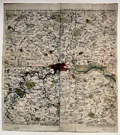
An Accurate Map Of The Country Sixteen Miles Round London Drawn And Engrav’d From An Actual Survey..
Map originally in four parts and now neatly joined together on the verso to form one fold. Two corners reinforced but otherwise in fine condition. Date 1764 in faded ink in lower margin.
£100.00
Details
GIVE AWAY MAP SUPPLEMENT, 1764
Date
[n.d. but c.1764].
Item Description
Folding hand coloured, engraved map. 16.5 x 18 inches.
Notes
Howgego dates this anonymous map to c.1755. It was certainly known to have been published as a supplement to the the January, April, May and June 1764 parts of the Gentleman's Magazine. in four separate sections, and is noted at the foot of the initial contents pages of those issues. It indicates distances from London (shown in solid hatching) at one mile intervals, with a dotted line to indicate the limits of the Penny Post. It extends from Cheshunt to Coulsdon and Harlington to Purfleet. Symbols indicate churches, gentlemen's seats, water and windmills and parks, etc. An attractive map, put together from the four give-away supplements to The Gentleman's Magazine.
[Stock No. 21561]
Subjects
18th Century • Folding Maps • Journals • London • Topography